
Fayl:City of London skyline from London City Hall - Oct 2008.jpg

Sınaq göstərişi ölçüsü: 800 × 420 piksel. Digər ölçülər: 320 × 168 piksel | 640 × 336 piksel | 1.024 × 537 piksel | 1.280 × 671 piksel | 2.560 × 1.343 piksel | 8.441 × 4.427 piksel.
Faylın orijinalı (8.441 × 4.427 piksel, fayl həcmi: 10,81 MB, MIME növü: image/jpeg)
Xülasə
| İzah |
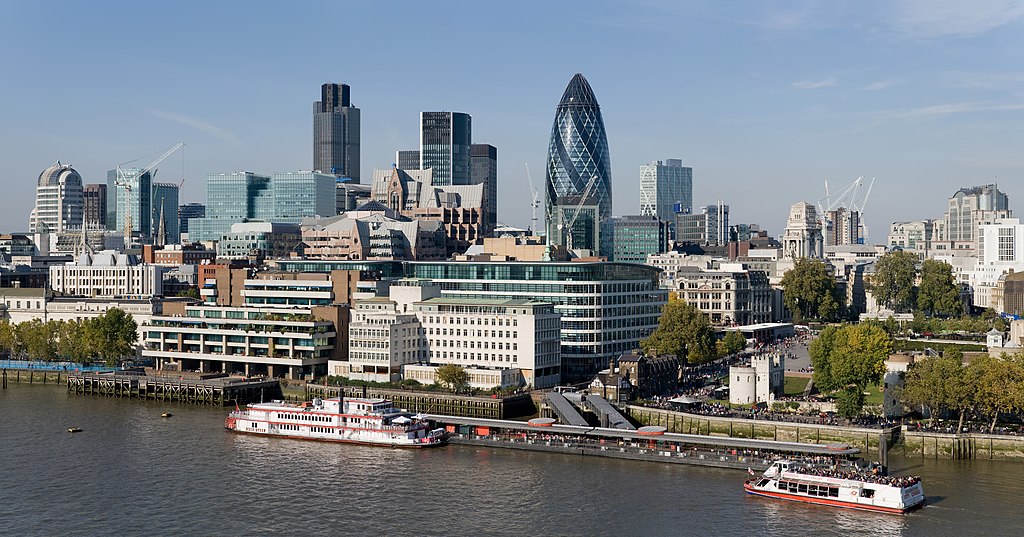
English: The City of London skyline as viewed toward the north-west from the top floor viewing platform of London City Hall on the southern side of the Thames. In the foreground: Dixie Queen and Millennium Time at Tower Millennium Pier. This is a 5 segment panoramic image taken by myself with a Canon 5D and 24-105mm f/4L IS lens. |
| Tarix | |
| Mənbə | Öz işi |
| Müəllif | Diliff |
| İcazə (Faylın təkrar istifadəsi) |
Summary:In using this image or any subsequent derivatives of it, you are required to release the image under the same license. As such, any reproduction of this image, in any medium, must appear with a copy of, or full URL of the license.Attribution of this image to the author (DAVID ILIFF) is also required, preferably in a prominent location near the image.No other conditions may be added to, or removed from this license without the permission of the author and copyright holder.Suggested attribution: "Photo by DAVID ILIFF. License: CC BY-SA 3.0"Please review the full license requirements carefully before using this image. If you would like to clarify the terms of the license or negotiate less restrictive commercial licensing outside of the bounds of GFDL/CC-BY-SA, please contact me by email, or if you don't have a Wikipedia account you can either leave a message on my talk page with your contact details and your request, or you can contact me on Facebook. Please also send a 'friend request' to ensure that I am aware of your message. |
| Digər versiyalar |
  |
| Camera location | | View this and other nearby images on: OpenStreetMap |
|---|
Lisenziya
I, the copyright holder of this work, hereby publish it under the following licenses:
Bu fayl Creative Commons Attribution-Share Alike 3.0 Unported lisenziyası altında yayımlanır.
- Azadsınız:
- paylaşmaq – əsəri köçürmək, paylamaq və ötürmək üçün
- remiks etmək – əsəri adaptasiya etmək
- Aşağıdakı şərtlərə riayət etməklə:
- istinad – Müvafiq kredit verməlisiniz, lisenziyaya bir keçid verməlisiniz və dəyişikliklərin olub olmadığını bildirməlisiniz. Bunu hər hansı bir ağlabatan şəkildə edə bilərsiniz, ancaq lisenziyalaşdırıcının sizi və ya istifadənizi təsdiqləməsini təklif edən bir şəkildə deyil.
- bənzər paylaşma – Əsəri remix edirsinizsə, dəyişdirirsinizsə və ya üzərində iş aparırsınızsa, öz töhfələrinizi orijinalda olduğu kimi eyni və ya uyğun lisenziya altında yayımlamalısınız.

|
Bu sənədi GNU Azad Sənədləşdirmə Lisenziyası, Versiya 1.2 və ya Azad Proqram Fondu tərəfindən nəşr olunan hər hansı sonrakı versiya şərtlərinə əsasən dəyişməz bölmələr, ön qapaq mətnləri və arxa qapaq mətnləri olmadan köçürmək, yayımlamaq və / və ya dəyişdirmək üçün icazə verilir; Lisenziyanın bir nüsxəsi GNU Azad Sənədləşdirmə Lisenziyası adlı hissəyə daxil edilmişdir. |
İstədiyiniz lisenziyanı seçə bilərsiniz.
Assessment
|
This image has been assessed using the Quality image guidelines and is considered a Quality image.
|
| Annotations | This image is annotated: View the annotations at Commons |
Faylın tarixçəsi
Faylın əvvəlki versiyasını görmək üçün gün/tarix bölməsindəki tarixlərə klikləyin.
| Tarix/Vaxt | Kiçik şəkil | Ölçülər | İstifadəçi | Şərh | |
|---|---|---|---|---|---|
| indiki | 07:41, 24 iyun 2012 | | 8.441 × 4.427 (10,81 MB) | Tim! | Reverted to version as of 12:54, 12 October 2008 |
| 12:54, 12 oktyabr 2008 |  | 8.441 × 4.427 (10,81 MB) | Diliff | {{Information |Description={{en|1=The City of London skyline as viewed toward the north-west from the top floor viewing platform of London City Hall on the southern side of the Thames. This is a 5 segment panoramic image taken by myself with a Canon 5D an |
Fayl keçidləri
Aşağıdakı 2 səhifə bu faylı istifadə edir:
Faylın qlobal istifadəsi
Bu fayl aşağıdakı vikilərdə istifadə olunur:
- af.wikipedia.org layihəsində istifadəsi
- ar.wikipedia.org layihəsində istifadəsi
- az.wikipedia.org layihəsində istifadəsi
- be-tarask.wikipedia.org layihəsində istifadəsi
- be.wikipedia.org layihəsində istifadəsi
- bg.wikipedia.org layihəsində istifadəsi
- bs.wikipedia.org layihəsində istifadəsi
- ca.wikipedia.org layihəsində istifadəsi
- cy.wikipedia.org layihəsində istifadəsi
- de.wikipedia.org layihəsində istifadəsi
- en.wikipedia.org layihəsində istifadəsi
- Tower Millennium Pier
- Wikipedia:WikiProject UK geography
- Wikipedia talk:WikiProject UK geography
- User:Diliff
- Portal:London/Pictures/Wikipedia featured pictures
- Wikipedia:Featured pictures/Places/Panorama
- Portal:United Kingdom/Featured picture
- Wikipedia:WikiProject UK geography/Announcements
- Wikipedia:Featured pictures thumbs/13
- Metropolis
- Wikipedia:Featured picture candidates/October-2008
- Wikipedia:Featured picture candidates/City of London skyline
- Wikipedia:Wikipedia Signpost/2008-11-08/Features and admins
- Wikipedia:Wikipedia Signpost/2008-11-08/SPV
- Wikipedia:Picture of the day/June 2009
- Template:POTD/2009-06-08
- User talk:Diliff/Archive6
- List of central business districts
- Wake Up to Money
- User:Quibik/Montage
- Portal:London/Featured picture
- Portal:London/Featured picture/12
- User talk:Sabrebd/Autoarchive 4
- Talk:United Kingdom/Archive 27
- User talk:Ottoniel B
- Portal:United Kingdom/Featured picture/47
- Talk:London/Archive 11
- Template:User Part Time Resident-London
- User:DexDor/Categorization
Bu faylın qlobal istifadəsinə baxın.