
Fayl:Districts of the Bahamas (Labeled).png
Sınaq göstərişi ölçüsü: 578 × 600 piksel. Digər ölçülər: 231 × 240 piksel | 463 × 480 piksel | 825 × 856 piksel.
Faylın orijinalı (825 × 856 piksel, fayl həcmi: 21 KB, MIME növü: image/png)
.png)

|
This locator map image could be re-created using vector graphics as an SVG file. This has several advantages; see Commons:Media for cleanup for more information. If an SVG form of this image is available, please upload it and afterwards replace this template with
{{vector version available|new image name}}.
It is recommended to name the SVG file “Districts of the Bahamas (Labeled).svg”—then the template Vector version available (or Vva) does not need the new image name parameter. |
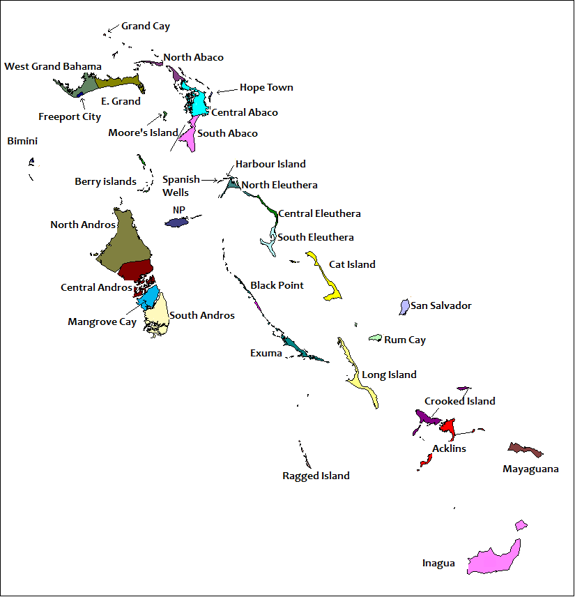
| İzah | == Summary == Created by Rarelibra for public domain use. Created using MapInfo Professional v7.5 and referencing various Bahamian map sources. en:Category:Maps of the Bahamas |
| Tarix | (UTC) |
| Mənbə | |
| Müəllif |
|
| Bu təsvirin redaktəsi, orijinala əsaslanaraq rəqəmsal qaydadadır. Dəyişiklik: Labells on the various Districts of The Bahamas have been placed.. İlkin təsvir buradadır: Districts of the Bahamas.png. Redaktə etdi Uniongreen113.
|
I, the copyright holder of this work, hereby publish it under the following license:
| Mən, bu əsərin müəllif hüquqlarının sahibi kimi, əsəri ictimai mülkiyyətə verirəm. Bu icazə bütün dünyada qüvvədədir. In some countries this may not be legally possible; if so: Bunun qanunla mümkün olmadığı hallarda: İstənilən şəxsə, istənilən məqsəd üçün, qanunlar tərəfindən qadağan edilməyincə, heç bir şərt qoymadan bu işdən istifadə haqqını bağışlayıram. |
Orijinal yükləmə gündəliyi
This image is a derivative work of the following images:
- File:Districts_of_the_Bahamas.png licensed with PD-self
- 2006-11-05T20:18:13Z Stanmar 825x856 (23099 Bytes) {{Information| |Description= == Summary == Created by [[:en:User:Rarelibra|Rarelibra]] for public domain use. Created using MapInfo Professional v7.5 and referencing various Bahamian map sources. [[:en:Category:Maps of the B
Uploaded with derivativeFX
Faylın tarixçəsi
Faylın əvvəlki versiyasını görmək üçün gün/tarix bölməsindəki tarixlərə klikləyin.
| Tarix/Vaxt | Kiçik şəkil | Ölçülər | İstifadəçi | Şərh | |
|---|---|---|---|---|---|
| indiki | 16:19, 16 iyun 2022 | | 825 × 856 (21 KB) | M.Bitton | Per request on en:Wikipedia:Graphics_Lab/Map_workshop#Request_spelling_fix_for_File:Districts_of_the_Bahamas_(Labeled).png |
| 19:54, 27 iyun 2010 |  | 825 × 856 (36 KB) | Uniongreen113 | {{Information |Description=== Summary == Created by Rarelibra for public domain use. Created using MapInfo Professional v7.5 and referencing various Bahamian map sources. en:Category:Maps of the Bahamas |Source=*[[:File:Distri |
.png)
Fayl keçidləri
Aşağıdakı səhifə bu faylı istifadə edir:
Faylın qlobal istifadəsi
Bu fayl aşağıdakı vikilərdə istifadə olunur:
- en.wikipedia.org layihəsində istifadəsi
- eo.wikipedia.org layihəsində istifadəsi
- fo.wikipedia.org layihəsində istifadəsi
- hu.wikipedia.org layihəsində istifadəsi
- id.wikipedia.org layihəsində istifadəsi
- is.wikipedia.org layihəsində istifadəsi
- it.wikipedia.org layihəsində istifadəsi
- la.wikipedia.org layihəsində istifadəsi
- lfn.wikipedia.org layihəsində istifadəsi
- ms.wikipedia.org layihəsində istifadəsi
- pt.wikipedia.org layihəsində istifadəsi
- sd.wikipedia.org layihəsində istifadəsi
- sv.wikipedia.org layihəsində istifadəsi
- tl.wikipedia.org layihəsində istifadəsi
- vi.wikipedia.org layihəsində istifadəsi
.png)